
River Map Of India
-by Abhrajita Mondal
–Reading Time – 7 min Approx
So, if you want to get information on the river map of India, you are at the right page. The Indian River system is divided into Peninsular Rivers and the Himalayan Rivers. Moreover, the Peninsular Rivers originate from the Western Ghats and drain into the Arabian sea or the Bay of Bengal. Additionally, as the name suggest, the Himalayan Rivers originate in the Himalayas, and drain flow along the Northern plains. You should know about the major River systems. The most important Peninsular Rivers are Mahanadi, Cauvery, Krishna, Godavari, Narmada, and Tapti.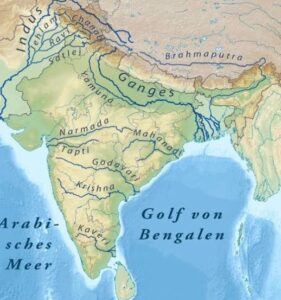
And, the most important Himalayan River system, includes the Indus River system, Ganga, Yamuna, and Brahmaputra. The rivers originate from the Himalayan Glaciers. But the Peninsular Rivers are fed by rainfall, and may dry up in the summer months. So, by now you have understood how vast the river map of India is. So, you can say that India is the land of rivers. There are so many of them. Apart from the main rivers, the rivers originating from the Himalayas are quite vast in nature. They also have their own tributaries. The rivers of India are extremely important for the livelihood of the people. They assist in trade, and also generate hydel power. Moreover, they are used as channels of communication.
You will be amazed to know that many civilizations had come up on the banks of these rivers. Agriculture in India, is also largely dependent on the water obtained from these rivers. You will also come across various industries like that of cotton, textiles, sugar, and jute, which are dependent on the Indian river system. Furthermore, the river systems such as the ‘Saptasindhu’ are an important part of the Vedic culture. They play important roles as a part of the Rig Veda. The Vedic texts speak of rivers, seas, oceans and various such water bodies. You should read about them in details. Read about the major rivers of India here.
Major Himalayan Rivers of India:
-
Ganga
The Ganga is the most worshipped river in India. It is worshipped as Goddess Ganga. However, it is one of the most polluted rivers as well. The River Ganga originates in the Gangotri glaciers. It is also the third largest river in the world, as well. The river passes through some major cities like Patliputra, Kashi, Patna, Farrukhabad, Fatehgarh, Allahbad, Varanasi, Kolkata, Badrinath, Haridwar, Kanpur, Kannauj, and the Chakeri. Additionally, it is also known to create the largest Delta called the Sunderbans. It has many tributaries, and the most important ones are Ghaghra, Tamsa, Gomti, Yamuna, and Koshi, and they all merge into the Bay of Bengal.
-
Indus
The Indus River has given rise to a number of civilizations, and has huge historical value. ‘India’ the name has also been derived from ‘Indus’. It originates from the Tibetan Plateau. Moreover, the river passes through Leh, Hyderabad in Pakistan, and Sukur. The most important tributaries are the Balram river, Gilgit, Jhelum, Ravi, Sutlej, Beas, Chenab, and Dras. Furthermore, the river tributaries merges into the Arabian sea. Three countries have the river passing through its boundaries, Pakistan, India, and China. It is also called Sindhu.
-
Yamuna
The Yamuna runs parallel, to the Ganga. And some also refer to it as the twin of the Ganga. The name may have originated from the word ‘YAMA’, which means ‘twin’. It is also quite long, like the Ganga. And it is also the second largest tributary of the Ganga. The important Taj Mahal is located on the banks of the Yamuna River. The major cities, through which it passes through are Etawah and Auraiya, in Uttar Pradesh, along with, Mathura, and New Delhi. Just like the Ganga, the Hindus worship Yamuna as well. You should also know about its origins. The Yamuna originates from the Yamunotri glacier. –
The river Yamuna accounts for more than 70% of Delhi’s water supply. The Yamuna has many tributaries. While most river drain into the sea, the Yamuna merges with Ganga in Allahabad. Moreover, you will also hear it, been referred as the ‘Jamuna’. While studying the river map of India, it is important to read about the Yamuna.
-
Brahmaputra
Millions of people in Assam and Guwahati, are dependent on this river. It is also referred to as the lifeline of the states like the ones stated above. Many people are dependent on the river for their daily livelihood. However, it does not originate in India. The river originates in the Angsi Glacier in Tibet. It enters Arunachal Pradesh and then Assam. Moreover, the river merges into the Padma River in Bangladesh. Some people also refer to it, as the Tsangpo- Brahmaputra. More than 6 lac people live on the riverine islands of the Brahmaputra. Furthermore, it also has the largest volume of water, amongst all the rivers in India. These are amongst the major rivers of India.
Peninsular Rivers on the River Map of India:
-
Mahanadi
It is the first of the peninsular rivers, that you are going to read about today. It is a major river in East-Central India. It originated from the Sihava mountains in Chattisgarh. It flows through cities like Cuttack, Sambalpur, and Banki. Millions of people depend on the water for drinking and irrigation. It is also referred to as the ‘Ruins of Odisha’. The reason being that, it used to cause huge devastation in the form of floods, before, the construction of Hirakud Dam.
-
Godavari
The second-longest river after the Ganga, it also finds mention in several Hindu scriptures. It also has rich cultural heritage. Its origin is in Tryambakeshwar in Maharashtra. It passes through some of the major towns, like Rajahmundry, Nashik, Nanded, and Nizamabad. You will find the endangered Olive Ridley turtles nesting on the Krishna Godavari basin. It fares quite prominently amongst the conservationists. The river merges into the Bay of Bengal.
-
Krishna
It is again the fourth biggest river, in terms of the water that flows into it. Some people even call it Krishnaveni. The origin of the river is Mahabaleshwar. The river passes through some of the major towns called Sangali, Konya, and Vijayawada. The states of Maharashtra, Karnataka, Telangana, and Andhra Pradesh receive water for various types of utility from the River Krishna. There are at least three dams that have been built on the river. They are Nagarjun Sagar Dam, Dhom Dam, and Narayanpur Dam. Moreover, you will be amazed to know that the delta formed by the river, is the most fertile of all. Vijayawada, is the largest city on the banks of the River Krishna. It eventually flows into the Bay of Bengal.
-
Cauvery
It is also spelled as Kaveri. Water from the river, is used in several households, for irrigation, and community purposes in South India. It origins from the Talakaveri, in the Western Ghats. The most important towns on the banks of the river are Kushalnagar, Mysuru northern suburbs, Srirangapatna, Karur, and Tiruchirapalli as well. The river eventually flows into the Bay of Bengal.
-
Narmada and Tapti
It also flows into the Arabian sea. It mainly flows through Central India. The Tapti flows parallel to the Narmada, from its south part. Madhya Pradesh, Maharashtra, and Gujarat are the states through which the river flows. The Tapti also flows through the states of Maharashtra and Gujarat. It flows into the Gulf of Khambhat.
So, by now you know the names of all the important river systems in India. Rivers play a very important role in the lives of the people residing in India. Apart from providing drinking water supply, the water is used in household work, in agriculture, and to generate power. Many religious festivals also take place on the banks of rivers. The nine major rivers of India are listed above for your reference.
Google River Map of India:
When you peep into the Google River Map of India, you will find all these rivers and more. They feature very prominently on the Indian maps. Google Earth is free to use, and it uses satellite images to find out about different features on the earth. The rivers also show up prominently on the map. You can use it on your desktop, smartphones, and laptops as well. The rivers are the natural resources of India.
You will be amazed to know, that they are the lifelines in the Indian sub-continent. The various religious sects worship the rivers as well. In fact, many mythological stories are intertwined with the rivers. You can read about the rivers in texts such as Mahabharata and the Ramayana. Many rivers not listed above, are mentioned in the Mahabharata. The rivers called Aril in Bareilly, Tamsa in Ayodhya, Sot in Badaun, the Manorama in Basti, Varuna in Varanasi, Sai in Unnao, and Ami in Gorakhpur. These rivers originate from the flat plains and find mention in the Ramayan and Mahabharata.
These are the rivers which found mention in the epics mentioned above. So, the government is trying to revive them and keep them flowing. They are a part of the Indian Heritage, as well.
-by Abhrajita Mondal
Dear Reader, Hope you liked the post. If you think our initiative “The Creative Post” is worth supporting, then please support us by paying the amount you think we are worthy of. We believe, the value of content should be decided by the consumer. Hence we request you to evaluate our worth and pay accordingly by Clicking Here.
